


Geocam Free
Geocam Free açıklaması
Geocam by Wazar is the leading geophoto and video application for Android. It uses augmented reality to show on top of your camera a layer of geographical information such as Compass orientation, GPS position and different phone inclinations like a theodolite optical instrument.
What you can do with Geocam:
* Geo-Pictures: photos that have an extra layer of geographical data such as GPS position, compass orientation, pitch, roll, altitude, etc. This data is added into the EXIF metadata and can selectively be drawn on images as an overlay. You can see all you pictures on Google Maps or on Google Earth on your personal computer with the export feature. You can share those albums with anyone who can run Google Earth.
* Geo-Videos (Pro only): the first and only app to let you record videos with an embed layer of geographical data. A useful addition to pictures. With Geocam Studio (available on geocam.wazar-apps.com), customize and export these videos and share them.
* Bearings: Geocam is an accurate measure tool. It shows your compass orientation (choose between magnetic or geographic North), your inclination and elevation with readable cursors (like a cockpit HUD). It can be used in terrain mapping, on a glide, sailing, mountain biking...
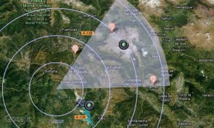
* Geo-Caching: prepare a list of key places in an area and view them with your camera on augmented reality: name, distance. You will not require a data connection offline so it can be used when hiking abroad, when visiting another city... This will help you make sure you are going in the right direction and give you remaining distance. You can also add markers during your hike with the "Add here" option, for example to flag the base camp, a water source, or anything interesting you find on your way.
* Measurements: Evaluate the distance to any object with the triangulation feature. You can also measure its height once the distance is known. This is not done by showing any unreadable cursor on the screen, but with mathematical formulas. Choose between metric and imperial measure systems.
Geocam supports extensive customisation including:
* Selecting which indicators to display on the HUD and whether to save them or not on pictures
* Metric and imperial systems
* GPS Formats: Decimal degrees, degrees/minutes/second, MGRS, UTM
* True north or magnetic north
* Degrees or Mils compass readings
* Percentage or degree slopes
* Calibrating "zero" pitch and roll to custom values to measure differences
* Different themes including a "cockpit" style or a "hi-vis" style
This is a free edtition, and with Geocam Pro, you get:
* No Ads
* Record and playback augmented video. This is a powerful tool in addition to Geophoto to record the topology of any area for further reference, as you can add your own audio commentary. Augmented video is an exclusivity of Geocam by Wazar.
* Export KMZ files to Google Earth, to display your pictures and markers in their original location and orientation, and share them easily.
IMPORTANT NOTE: If you are facing an issue, we cannot help you if you only leave a review. Do get it touch by email so we can hep you. We do reply to all emails and regularly push out fixes to reported problems. By all means please do get in touch if you are experiencing difficulties.
Wazar tarafından GeoCam Android için önde gelen Geophoto ve video uygulamasıdır. Böyle Pusula yönü, GPS konumu ve bir teodolit optik alet gibi farklı telefon eğilimleri gibi kameranın üstündeki coğrafi bilgi tabakası göstermek için genişletilmiş gerçeklik kullanır.
Eğer GeoCam ile neler yapabilirsiniz:
* Geo-Resimler: Bu veri EXIF meta eklenir ve seçici bir kaplama olarak görüntüleri çizilebilir vb GPS konumuna, pusula yönü, eğimi, dönüşü, yükseklik, coğrafi verilerin fazladan bir katman var fotoğraflar. Sen ihracat özelliği ile kişisel bilgisayarınızda Google Earth, Google Maps üzerinde veya tüm resimleri görebilirsiniz. Google Earth'ü çalıştırabilirsiniz herkesle bu albümleri paylaşabilirsiniz.
* Jeo-Videolar (Pro sadece): ilk ve tek uygulama size coğrafi veriler embed tabakası ile video kaydetmek izin vermek. Resimlere yararlı bir ek. (Geocam.wazar-apps.com mevcuttur) GeoCam Studio ile özelleştirmek ve bu videoları ihracat ve bunları paylaşmak.
* Yataklar: GeoCam doğru bir ölçü aracıdır. Bu sizin pusula yönünü (manyetik veya coğrafi Kuzey arasında seçim), (bir kokpit HUD gibi) okunabilir imleçler ile eğim ve yüksekliğini gösterir. Bu bir kayma, yelken, dağ bisikleti üzerinde, arazi haritalama kullanılabilir ...
* Geo-Caching: bir alanda önemli yerlerin bir listesini hazırlamak ve artırılmış gerçeklik üzerinde kamera ile görüntülemek: isim, uzaklık. Başka bir şehir ziyaret ederken, yurt dışında yürüyüş zaman kullanılabilir böylece çevrimdışı veri bağlantısı gerekmez ... Bu size doğru yönde gidiyor emin olun yardımcı olmak ve size kalan mesafeyi verecektir. Ayrıca bayrak, örneğin, "Burada Ekle" seçeneği ile yürüyüş sırasında size yolda bulmak kamp, bir su kaynağı, ya da ilginç bir şey işaretlerini ekleyebilirsiniz.
* Ölçümler: nirengi özelliği ile herhangi bir nesneye olan mesafeyi değerlendirin. mesafe bilindiği kez de yüksekliğini ölçebilirsiniz. Bu ancak matematiksel formüller ile, ekranda herhangi bir okunamayan imleci göstererek yapılmaz. metrik ve emperyal ölçü sistemleri arasında seçim yapın.
GeoCam dahil olmak üzere geniş özelleştirme destekler:
* Hangi göstergeler seçilmesi HUD görüntülemek için ve resimlerin üzerine onları kurtarmak edip etmeyeceğine
* Metrik ve emperyal sistemleri
* GPS Biçimleri: Ondalık derece, derece / dakika / saniye, MGRS'yi, UTM
* Gerçek kuzey veya manyetik kuzey
* Derece veya Mils pusula okumaları
* Yüzde veya derece eğimleri
farklılıkları ölçmek için özel değerlere * Kalibrasyon "sıfır" pitch ve roll
Bir "kokpit" tarzı ya da bir "hi-vis" tarzı da dahil olmak üzere * Farklı temalar
Bu ücretsiz bir edtition ve GeoCam Pro ile elde edersiniz:
* Reklamsız
* Kayıt ve oynatma artar bir video. Bu, kendi ses yorum ekleyebilirsiniz olarak daha fazla referans için herhangi bir alanda topolojisini kaydetmek için Geophoto ek olarak güçlü bir araçtır. Augmented Video Wazar tarafından GeoCam bir münhasırlık olduğunu.
Google Earth'e * İhracat KMZ dosyaları, özgün konumlarına ve yönde resimlerinizi ve işaretçileri görüntülemek ve bunları kolayca paylaşmak için.
ÖNEMLİ NOT: bir sorunla karşı karşıya iseniz, sadece bir inceleme bırakırsanız, biz size yardımcı olamaz. Size Hepatit olabilir bu yüzden e-posta yoluyla temas olsun. Biz tüm e-postalara cevap ve düzenli olarak bildirilen sorunlar için düzeltmeler dışarı itmek yoktur. Zorluklarla yaşıyorsanız tüm yollarla temasa geçebilirsiniz.
Geocam Free - Sürüm 5.34
(10-04-2020)Geocam Free - APK Bilgisi
APK sürümü: 5.34Paket: com.mywayGeocam Free uygulamasının en son sürümü
Diğer sürümler


Aynı kategorideki uygulamalar
 3.694.324.073.674.394.4
Hoşuna gidebilecekler...